"High-resolution, multispectral images of Earth's surface."
"Joins Aqua, Parasol, Aura, and Calipso in A-Train; meteorological satellite, carries single radar to obtain the reflectivity of clouds."
"High resolution imaging satellite; obtain images (with resolution of 0.82 meters) of locations chosen by Israeli military or worldwide commercial clients; in Jan. 2001 Ministry of Defense bought rights to all imaging of Israel and territories within 2,000 km around Israel."
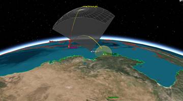
?. . . Provide atmospheric data daily in real time over thousands of points on Earth for both research and operational weather forecasting by measuring the bending of radio signals from the U.S. Global Positioning System (GPS) as the signals pass through Earth's atmosphere.?
?. . . Provide atmospheric data daily in real time over thousands of points on Earth for both research and operational weather forecasting by measuring the bending of radio signals from the U.S. Global Positioning System (GPS) as the signals pass through Earth's atmosphere.?
?. . . Provide atmospheric data daily in real time over thousands of points on Earth for both research and operational weather forecasting by measuring the bending of radio signals from the U.S. Global Positioning System (GPS) as the signals pass through Earth's atmosphere.?
?. . . Provide atmospheric data daily in real time over thousands of points on Earth for both research and operational weather forecasting by measuring the bending of radio signals from the U.S. Global Positioning System (GPS) as the signals pass through Earth's atmosphere.?
?. . . Provide atmospheric data daily in real time over thousands of points on Earth for both research and operational weather forecasting by measuring the bending of radio signals from the U.S. Global Positioning System (GPS) as the signals pass through Earth's atmosphere.?


.png)